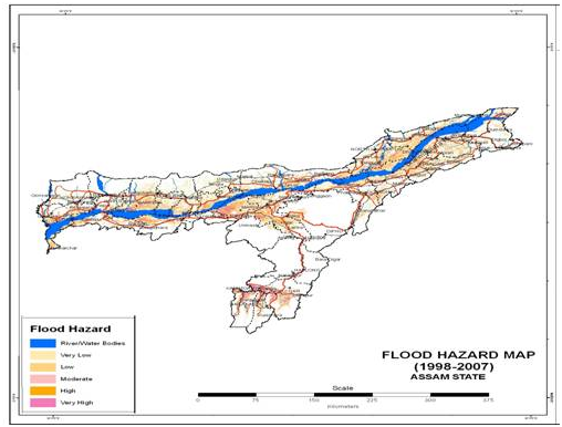
Assam with its vast network of rivers is prone to natural disasters like flood and erosion which has a negative impact on overall development of the state. The Brahmaputra and Barak River with more than 50 numbers of tributaries feeding them, causes the flood devastation in the monsoon period each year. The flood and erosion problem of Assam is singularly different from other states so far as extent and duration of flooding and magnitude of erosion is concerned and is probably the most acute and unique in the country. The flood prone area of the state as assessed by the Rastriya Barh Ayog (RBA) is 31.05 Lakh Hectares against the total area of state 78.523 Lakh Hectares i.e. about. 39.58 % of the total land area of Assam. This is about 9.40% of total flood prone area of the country. Records show that average annual area affected by flood is 9.31 Lakh Hectares. The flood prone area of the country as a whole stands at about 10.2 % of the total area of the country, but flood prone area of Assam is 39.58 % of the area of the state. It signifies that the flood prone area of Assam is four times the national mark of the flood prone area of the country.
During post independence period, Assam faced major floods in 1954, 1962, 1972, 1977, 1984, 1988, 1998, 2002, 2004 and 2012. Almost every year three to four waves of flood ravage the flood prone areas of Assam. Average annual loss due to flood in Assam is to the tune of Rs. 200.00 Crores and particularly in 1998, the loss suffered was about Rs. 500.00 Crores and during the year 2004 it was about Rs. 771.00 Crores.
| Period | Average Annual Area Flooded ( in Mha) | Flooded Crop area as % of Total Inundated area | Average Annual Population Affected | Average Annual Damage (Rs in lakh) | Value of Crop lost as % of Total Damage | |
|---|---|---|---|---|---|---|
| Total | Cropped | |||||
| 1953 – 59 | 1.13 | 0.10 | 8.85 | 860,000 | 586 | 66% |
| 1960 – 69 | 0.75 | 0.16 | 21.33 | 15,20,000 | 757 | 92% |
| 1970 – 79 | 0.87 | 0.18 | 20.69 | 20,00,000 | 1,518 | 89% |
| 1980 – 88 | 1.43 | 0.40 | 28.05 | 45,50,000 | 14,552 | 96% |
| 1999 – 05 | 1.07 | 0.38 | 5.65 | 45,86,000 | 71,717 | 34% |
The flood problem of the state is further aggravated due to flash floods by the rivers flowing down from neighbouring states like Arunachal Pradesh and Meghalaya. During the year 2004 and 2014 the south bank tributaries of Brahmaputra in lower Assam, experienced flash floods of high magnitude due to cloud burst in the catchment areas in Meghalaya. During the month of August, 2011, due to cloud burst in the catchment area of Arunachal Pradesh the river Gainadi and Jiadhal also experienced flash flood of very high magnitude. These flash floods caused large scale devastation in vast areas including losses of human lives.
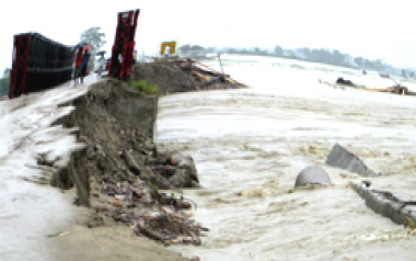
Another major problem being faced by the state of Assam is bank erosion by the river Brahmaputra, Barak and its tributaries. Damages caused due to erosion runs into several hundred crores every year. Bank erosion by the rivers has been a serious issue since last six decades as more than 4.27 Lakh Hectares of land was already eroded away by the river Brahmaputra and its tributaries since 1950, which is 7.40 % of area of the state. As assessed, the annual average loss of land is nearly 8000 Ha. The width of river Brahmaputra has increased up to 15.00 Km at some places due to bank erosion. The surveys carried out at different periods reflect an alarming picture regarding widening of river Brahmaputra which is as follows:
Sl. | Survey period | Area covered by the river Brahmaputra |
|---|---|---|
1 | First survey (1912-28) | 3,870 km² |
2 | Second survey (1963-75) | 4,850 km² |
3 | Third survey (2006 NESAC): | 6,080 km² |
Breaches of embankment due to bank erosion by the rivers have become a common phenomenon. New areas are being affected by erosion every year. The riverine fertile agricultural lands of the state are reducing due to erosion, which has a very negative impact on the rural economy of the state.
The extent of damage due to bank erosion is alarming in nature which can be seen from the following table (as assessed by the Revenue Department):
Year | Area Eroded in Ha | Nos. of Villages affected in Nos. | Family affected in Nos. | Value of property (including land loss) |
|---|---|---|---|---|
2001 | 5348 | 227 | 7395 | 377.72 |
2002 | 6803 | 625 | 17985 | 2748.34 |
2003 | 12589.6 | 424 | 18202 | 9885.83 |
2004 | 20724 | 1245 | 62258 | 8337.97 |
2005 | 1984.27 | 274 | 10531 | 1534 |
2006 | 821.83 | 44 | 2832 | 106.93 |
